Wilmette Buoy
The Wilmette buoy serves many audiences. For the National Weather Service (www.weather.gov), buoy data are used to forecast wave and weather conditions; observe current conditions, and change forecasts when observations are not the norm as expected. Recreational users of the lake also benefit from the data provided by the buoy. Boaters, anglers, paddlers and surfers use the data to make decisions about their personal safety, i.e. assess conditions before traveling out for the day. Charter fisherman use to the data to make decisions about the safety of their customers and crew, and also which locations will be good for fishing depending on the current wind and wave conditions. Henry’s Sports and Bait shop (www.henryssports.com) in downtown Chicago and the Sheridan Shore Yacht Club (sheridanshoreyachtclub.com) in Wilmette played pivotal roles in helping deploy the buoy and anchor. The buoy was first deployed through a grant from the Great Lakes Observing System (www.glos.us) and the NOAA Coastal Storms Program (coastalstorms.noaa.gov).
Long Term Data Uses
develop prediction models
fill the gaps in water quality data
provides a picture of historic data
Information Recorded
- Air Temperature
- Water Temperature
- Relative Humidity
- Dew Point
- Wave Height
- Wave Direction
- Wave Period
- Wind Speed
- Wind Gust
- Wind Direction
- Atmospheric Pressure
- Solar Radiation
Air Temperature: degrees F – averaged over ten minutes
Owned by
Illinois-Indiana Sea Grant

Located four miles off Wilmette
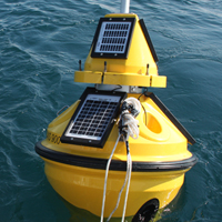
(42.135117, -87.65506)The buoy is located in about 44’ of water. Attached to a ton-weight concrete anchor, the 600-lb buoy can be seen with 10’ above the surface and 7’ below. The buoy is outfitted with a flashing beacon light as required by law.