Michigan City Buoy
The Michigan City buoy serves many audiences. For the National Weather Service (www.weather.gov), buoy data are used to forecast wave and weather conditions; observe current conditions, and change forecasts when observations are not the norm as expected. Recreational users of the lake also benefit from the data provided by the buoy. Boaters, anglers, paddlers and surfers use the data to make decisions about their personal safety, i.e. assess conditions before traveling out for the day. Charter fisherman use the data to make decisions about the safety of their customers and crew, and also which locations will be good for fishing depending on the current wind, wave and temperature conditions. The Michigan City Port Authority (www.mcmarina.org) and the Lake Michigan Indiana Department of Natural Resources office (www.in.gov/dnr/water/3592.htm) played pivotal roles in helping deploy the buoy and anchor. The buoy was first deployed through a grant from Illinois-Indiana Sea Grant. A grant from the Indiana Department of Natural Resources Coastal Management Program (www.in.gov/dnr/lakemich) allowed for the addition of the temperature chain.
Long Term Data Uses
develop prediction models
fill the gaps in water quality data
provides a picture of historic data
Information Recorded
- Air Temperature
- Water Temperature
- Relative Humidity
- Dew Point
- Wave Height
- Wave Direction
- Wave Period
- Wind Speed
- Wind Gust
- Wind Direction
- Atmospheric Pressure
- Solar Radiation
Air Temperature: degrees F – averaged over ten minutes
Owned by
Illinois Indiana Sea Grant and Purdue University Civil Engineering
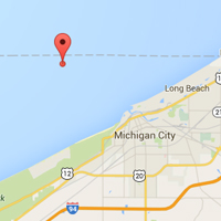
Located four miles off Michigan City
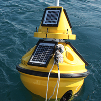
(N41.75532, W86.96847)The buoy is located in about 62’ of water. Attached to a ton-weight concrete anchor, the 500-lb buoy can be seen with 7’ above the surface and 8’ below. The buoy is outfitted with a flashing beacon light as required by law.